
There are some things that I’m definitely a snob about. Organized tours are one of those things. I have an incredibly pretentious attitude towards tours, probably developed from watching the bus loads of tourists disembark in Vienna every day and fighting through their crowds on my way to class. Because of that, I look down my nose at people who think group tours are the “authentic” way to see new places (I think I may have a small point, but mostly I should just get over myself).
Still, there’s no denying that they can be useful. There are several places in Ireland that I want to visit, but are only accessible by car. I’m not driving here. They drive on the left. I’m afraid to even ride my bike here. So, on Saturday evening, I booked a tour of the Boyne Valley for the next day (I also really enjoy doing things at the spur of the moment).
After walking from my apartment into town (the buses weren’t running yet and I was too cheap to take a taxi. It was actually a really lovely walk), I met the bus and the other tourists in front of the statue of Molly Malone. I guess if you’re going to be a tourist, do it up, right? I was the only American, but there were others from the Czech Republic, the Netherlands, France, and Mexico. Our tour guide was a hilarious woman named Sandra, who at one point smacked the Czech guy upside the head because he was messing with her. He couldn’t stop laughing for about five minutes, he was so shocked by what she’d done (she gave him a hug afterwards).
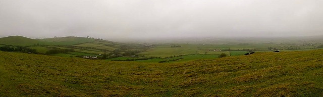
The first stop was the Hill of Tara, the original seat of the High King of Ireland. Although the site is incredibly ancient (thousands of years), there’s not that much to actually see; it’s more about the history of the place. Of course, there’s a hill. It’s not too steep, but apparently on clear days (this wasn’t) you can see really far into four different counties. Tara itself is better seen from the air, because the ancients formed the land itself into circles, or rings. When you’re walking on it it just seems like hilly ground, and can’t really be appreciated unless it’s seen from above.
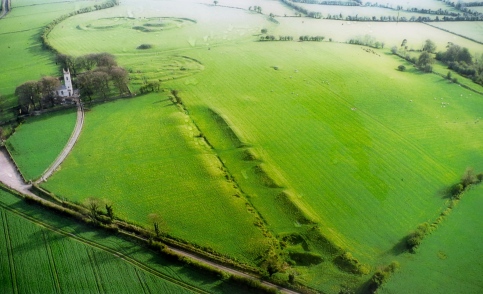
Walking up the hill you pass St. Patrick’s Church, then enter out onto the top of the hill. First there’s the Mound of the Hostages, a small, earthen mound with a door leading inside. The door is grated over, but if you peek in you can see stones with carvings. It took the experts awhile, but they finally realized the carvings are a map of Tara. According to Wikipedia, the Mound was used as a burial site up to 1600 or 1700 BCE, and it’s the resting place for 250-500 bodies, most often cremated. The whole structure was probably built between 2500 and 3000 BCE.


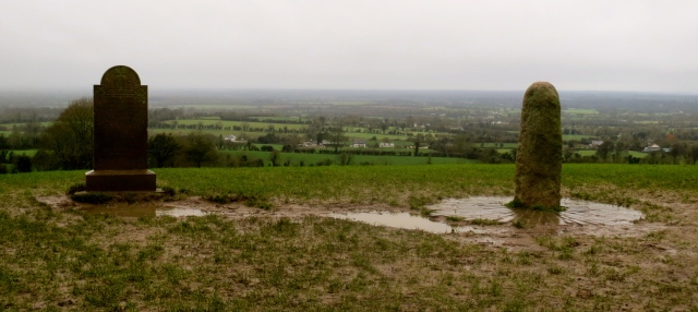
Further on, climbing up and down the rings in the earth, you come to the Forradh, or Royal Seat. Crowning this is the Lia Fáil, or Stone of Destiny (real life, folks!). This is where the High King was thought to be crowned, and legend says that if the true High King touches it, the stone will scream. To be perfectly honest, I don’t remember what the headstone commemorates.
After the Hill of Tara, we continued on to Trim Castle. Not the most scenic of Irish castles (it’s just a big box), but it does have an important history. It’s 800 years old, and I seem to remember our guide saying that it’s the oldest Anglo-Norman castle in Ireland, but I can’t verify that anywhere. More importantly, however, it served as the filming location for all of the castles in the movie Braveheart.

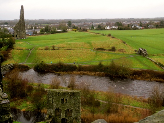
This is also where I bore the brunt of the actions of my countrymen, as the tour guide for the castle (not the same guide as the overall tour), who referred to us by our nationalities, turned to me and said, “Now don’t go climbing on anything, Miss America.”
From there we continued on to Loughcrew, another megalithic burial ground. This hill was much higher than Tara, and the way up was all wet and muddy. The wind had started to pick up, and it wasn’t raining, but it’s as if the wind itself was wet.

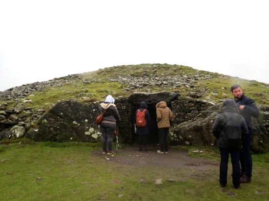
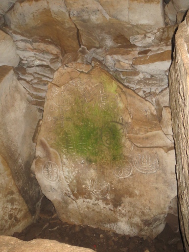
According to our tour-guide, these ruins are “the closest thing Ireland has to cavemen.” And no one has yet figured out what the carvings mean. It could be a form of language or record-keeping, storytelling, maps, or maybe they were just eating all of the wild mushrooms and herbs and drawing what was in their heads (this last also from the tour-guide).
After lunch at a cafe near Loughcrew, we headed to Monasterboice, an old monastery. The original settlement dates from the 5th century, but the remains of the buildings that still survive today are from the 14th century. The main points of interest here are the 10th century high crosses. There are three of them throughout the cemetery, and they’re stunning.


The tour ended in Drogheda, a nearby town, where we were supposed to have a couple hours, but due to delays (and getting to tour the inside of Trim Castle), we only had about 20 minutes to visit St. Peter’s Church, where the head of St. Oliver Plunkett is on display. So, you know, ending the day on a high note.

Pingback: Let’s go to Ireland: Tips from the podcast – Going Out Your Door